Thursday, July 3, 2014

Idaho - Craters of the Moon & Twin Falls

Lava fields from the road
On Saturday, June 21st we met my friend, Susie, and her husband and two children at the Sun Valley Club and had a delicious lunch on the patio.  It started to sprinkle just as we finished our meal and we moved into the building where our waiter delivered freshly baked chocolate chip cookies. Yum! Then Susie showed us the home where she grew up, and the condo her parents bought more than sixty years ago where Susie's family lived five days a week during the school year so her sons could go to a Montessori school for about seven years. We visited the home they bought last year, and we met Susie's father who had stopped by. Then Tom and I went on to Craters of the Moon.
The trail look like a ghost path up this cinder cone

This is 750,000 acres of land which has experienced intermittent lava flows starting 15,000 years ago and ending 2,000 years ago. Shoshone oral traditions indicate that some of their ancestors witnessed some of the last eruptions. We drove along Route 20 where we could see what looked like fields of rough, black rock, interspersed with lava that had grasses and other plants growing on it. We spent an hour or more driving through the park (we love the Senior Lifetime National Parks Pass - Tom calls it the Golden Geezer pass).
The landscapes can be eerily beautiful
This outcropping is about the size of a house

That is a big RV, to give you a sense of the landscape
In our language, the names for many lava formations come from Hawaiian - a'a and pahoehoe. In 1969 moon-bound astronauts (Alan Shepard, Edgar Mitchell, Eugene Cernan and Joe Engle) were brought to Craters of the Moon to train, although the moon's craters are more from meteor collisions than volcanic activity. They found the moon's surface was much more dusty than this area.
One can see why people who had only seen the moon
through telescopes thought the moon might be like this

Rather like Capitol Reef, there were not very many people at this park although as I recall, they said about 250,000 people visit it in a year. In the winter groups of school kids snowshoe into the park.

Lava with lichens growing on it
We saw evidence of volcanic eruptions in other places along our trip, through mostly sedimentary rock formations. There was Boulder Mountain between Bryce Canyon and Capitol Reef, and on our way back into Arizona we passed Sunset Crater Volcano National Monument. We'll have to visit there on another trip - it was ten minutes until closing when we drove by on our way home on this trip.

Being in this park reminded me of our family visit to Hawaii in 1993. My mother, who had been diagnosed with terminal lung cancer, invited her adult children to join her in Hawaii. We took a day trip to the Big Island to helicopter over an erupting volcano. From the helicopter we could gaze into the molten magma through holes in the lava fields and feel the heat. We flew over the coast where erupting hunks of lava exploded and created steam as they hit the ocean water. It felt primeval.

Our trip to Craters of the Moon meant that we spent our 'down day' driving about four hours there and back to Sun Valley, but the dramatic scenery was worth it.

We ate dinner at the Pioneer Saloon in Ketchum, which everyone said must be experienced. It is a steak and potato place - Tom had the steak, I had the potato which was GIGANTIC. There was a mix of tourists and locals with lots of animal heads on the walls, including several mule deer trophies with 29 to 43 points (I know, odd numbers - the racks looked a bit deformed and were not matched on the two sides).
Can you see the double rainbow effect?
Birds were soaring below us and landing
on almost vertical rock faces

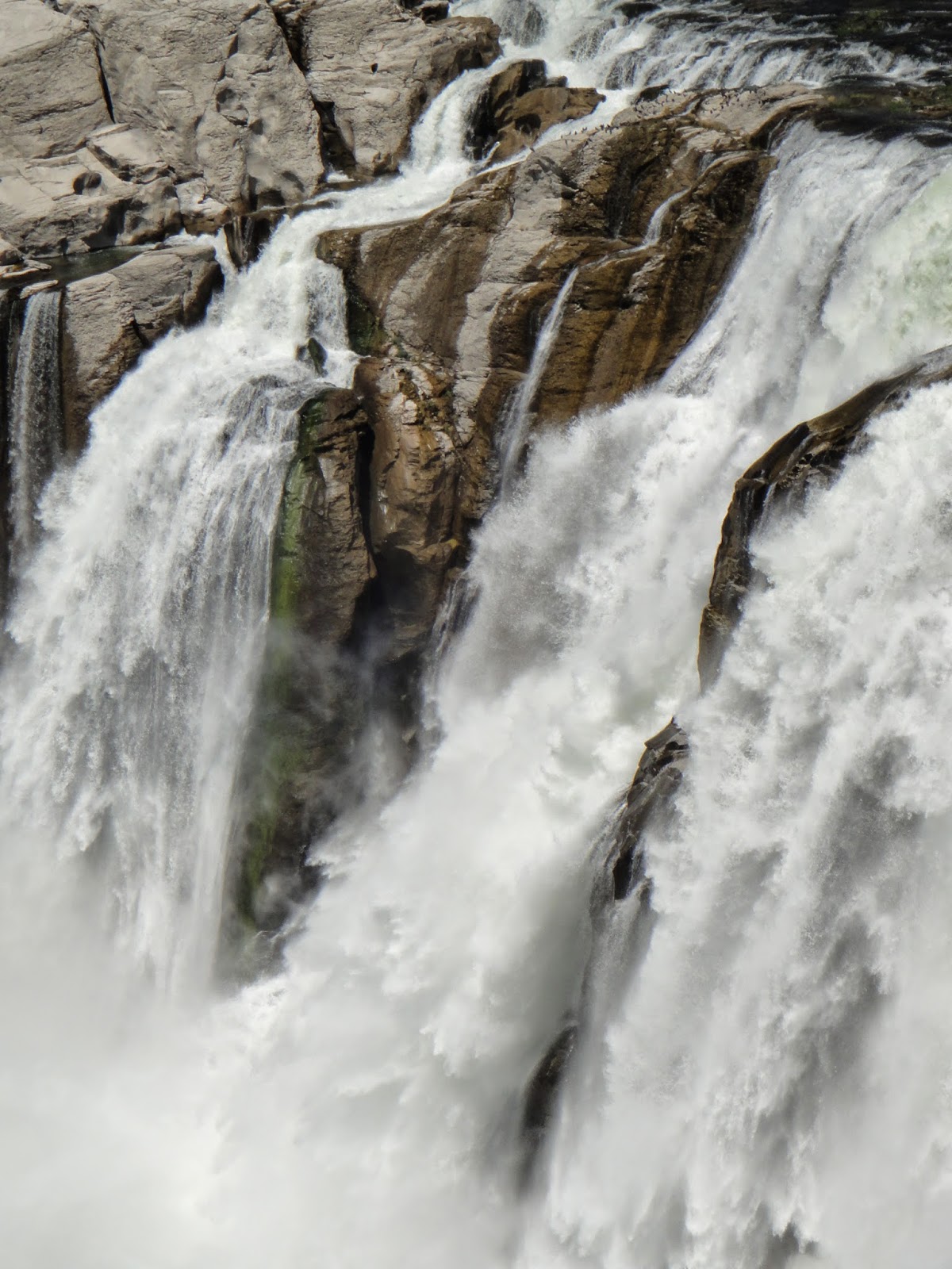
The next day we drove to Salt Lake City.  We detoured slightly to Twin Falls, Idaho to see where the Snake River goes over the Shoshone Falls. The day we were there the flow was a little below average at 3000 cubic feet per second. The falls are 212 feet high, higher than Niagara Falls, but with much less water flowing over them. There is a dam above the falls to generate electric energy (and regulate the flow below the falls) just like in Idaho Falls. You can go on a website to learn the current river flow, and to see real-time video to determine if the water flow is sufficient to pay the $3 fee to get into the park and walk down to the overlook.

The falls are high enough that salmon and sturgeon can go no further up the Snake River, and before there were big dams lower down the Snake, this was a great fishing area for Native Americans.

Below is the view looking down the river from the same platform - you can see the power plant at the right edge of the photo to get some perspective.
View to the west (downstream) of Shoshone Falls

As we drove to the park we passed a wide variety of homes. There were two massive homes with big fences and elaborate landscaping in the middle of relatively modest homes. As we crossed the river I took a photo out the window of the valley a few miles below the falls. It looks idyllic and you can see some of a golf course.

Twin Falls bridge

We continued on to Salt Lake City. As Susie's husband, Henry, said, you drive about an hour through the suburbs of Salt Lake before you actually arrive in the city. We again benefited from a free room, this time at a Marriott right downtown as a gift from my friend, Karen.

It was Sunday night in Salt Lake City. We ate at the highly recommended Bambara at the Hotel Monaco, just a block from our hotel (thanks Nancy, for the recommendation). We then walked a few blocks up the hill to explore Temple Square. Brigham Young established the location in 1847 and the city streets are numbered from the square - 100 S. Street (1 block south) or 300 W. Street (3 blocks west) with an occasional 4th S. Street thrown in to keep you on your toes. So an address might be 3220 300 S. St., a bit confusing at first.

Temple Square holds the Tabernacle (where the Mormon Tabernacle Choir performs), the Temple, an Assembly Hall (which we entered briefly, just before 9 pm), the Family History Library, two visitors centers and gardens and statues. Lots of tourists, primarily Asian, were taking photos, and outside the Square there were a number of polite beggars. They would 'bless us' even if we didn't give them anything. I didn't carry my camera with me that night, so I have no photos.

As we walked back to the hotel we passed a large grocery store below the street level, not something you see in every downtown. Earlier we had passed an upscale shopping center behind doors, and Brigham Young's house, where each of his many (some report 55) wives had their own quarters. The population of Salt Lake City itself is only about 190,000, but there are around 2.4 million along the 120 mile corridor from Brigham City to Nephi including Ogden and Provo. The National Security Agency recently built a mega Data Center in Bluffdale, and the Kennecott Mine at Bingham Canyon is humongous and can be seen from the highway miles away. It still produces copper, gold, silver and molybdenum.

We never saw the Great Salt Lake, which is saltier than the ocean and getting ever saltier because while three rivers flow in, no rivers flow out. It loses water only by evaporation. Despite the salinity, it is an enormous sanctuary for water birds. Monday morning we chose to tour the Capitol Building, which I'll tell you about in my next post.


Tuesday, June 24, 2014

Starting South

Those are Buddha statues lined up on the left -
8 rows radiate from the statue with beautiful
flowers lining both sides of each row
I've fallen behind on posting again - this trip is so full! Between driving 4-7 hours and unpacking and repacking most days, seeing the sights, visiting with family and friends, and trying to blog and peek at email, I'm not getting enough sleep. Oh well - it is certainly worth it.

We had a lovely time visiting my aunt Mary in Arlee.  We were in Missoula all three days of our visit, which included a visit to Rockin' Rudy's - a unique store with everything from vinyl records to psychedelic posters to jewelry and toys, Bequat caramels (made in Bozeman) and a great collection of cards, including the funniest postcards (see www.duckboy.com). It is a great place for a rainy afternoon.  We continued to have cool weather with intermittent sprinkles, which was fine by us - I think I may have said we hadn't had any real rain in Tucson since December.

We visited the Garden of One Thousand Buddhas in Arlee, and then drove up to St. Ignatius where the view convinced Mary to take a job at a small hospital on the reservation some 30 years ago after finishing medical school.
The Mission mountains - the view that made Mary
move to Montana

The tops of hills looked like beard stubble
against the sky
On Friday we drove south on 93 into Idaho. We drove past the remains of a big fire - there were naked trees for miles. We paused on top of the Lost Trails Pass, just over 7000' and I found a snow bank, so I accomplished another goal for the trip! I held some snow for the first time in 2014 (it didn't snow in Tucson this winter).

Lost Trails Pass runs along the Continental Divide and as we descended, we followed the Salmon River. We stopped at hot springs where the Civilian Conservation Corp built a bathhouse. The road was not heavily traveled and it was lovely. But the best was yet to come!
The Salmon River in Idaho

When we first saw the Sawtooth Mountains, I was stunned by their beauty. This was another OMG! moment, as moving as being in Antelope Canyon. The rugged majesty of these rocky peaks with year-round snow (at least for this year) brought tears to my eyes.

Once again, just like the first time I saw the Tetons, I wondered why I had gone to the Himalayas in 1983 and roughed it for a couple of weeks when such amazing mountains are right here in the United States with beds and running water nearby. My photographs don't do the mountains justice, so I tried to embed a video, but couldn't get it to work. Between my lack of skills and the internet connection where I am tonight at Zion, my desires have been frustrated. (You may have noticed the weird spacing on my posts, a result operator inexperience.) Perhaps I'll figure it out and be able to post the video later in the blog.

I want to go back and spend a few nights in Stanley, Idaho so I can spend a few days looking at those mountains. But it was getting late, so we continued on to Ketchum, a very cute resort town, and up to the Sun Valley Inn, where we
spent two nights and visited my friend, Susie Root Green.


This doorway faces the 'village' of Sun Valley
a walking mall with charming shops
The Inn is one of those grand dames - an elegant resort hotel from the 1940s, in this case built to remind you of being in the Alps. Besides the ski hills, there are indoor and outdoor ice-skating rinks (we paused to watch the Zamboni refreshing the ice on the outdoor rink), a band shell, a golf course and a little village of shops and restaurants.

'Cotton' at the band shell
The grounds are beautiful and incredibly well-manicured. In fact, there was the pungent smell of fresh mulch as we arrived at the very beginning of the summer season.
The 'cotton' pollen from the cottonwood trees was everywhere, blowing into clumps and collecting into little 'snowballs' and making everyone sneeze. Another way you know it is the beginning of the summer season is there are many of new employees who are just learning their jobs, especially in the restaurants. Their nametags indicate where they are from, and many are from Europe or South America. It is great to see they are getting to experience a gorgeous part of our country.

Friday, June 20, 2014

North to Montana

I've taken a little break from writing while we settled into Montana for the middle of our trip. We've passed a couple of markers - Tuesday was half-way through the trip both in terms of time and miles traveled, and as of tonight we have one week left on the road. Tuesday we moved from my brother, Patrick's, home at the Flaming Arrow outside Bozeman to my aunt's home in Arlee, MT, just under four hours away.  It has been nice to stay in the same place for three nights in a row at both places.

We've attained our goal of being in cooler weather! It was 44 degrees Tuesday morning and there has been plenty of rain with the precipitation being in the form of snow just above us on the mountains.

Going back to where I left off, last Friday, June 13th I was in Idaho for the first time (that I know of). That leaves six states I haven't been to yet - Alaska, North Dakota, South Dakota, Nebraska, Oklahoma and Kentucky. It was cool and quite breezy - we needed our jackets for the first time. We stayed in the Hilton Garden Inn (courtesy of my friend, Karen Clarke, who gave us the room with some of her points) which is on the Snake River, just a couple of blocks from the falls which give Idaho Falls its name. We walked along the river to Copper Rill, the restaurant recommended
A chia moose! Or a mossy moose?
by Emily at the front desk. The park that fronts the river bank is charming with this wonderful 'chia moose' and benches they call 'art to sit on.' The pony is my favorite. The rattlesnake bench seemed less inviting to me, but it is certainly photogenic, especially with what I'm guessing is a LDS temple across the river.

There are also gardens, and I was so happy to see (and smell!) the peonies! It reminded me that we had driven by a hedge of lilacs in bloom in Park City and I told Tom I wanted to go back so I could smell them. We didn't get to smell those lilacs, but when I arrived at my brother's on Saturday afternoon, there was a
vase of lilacs in our room,
and lilac bushes in the yard, so I enjoyed lilacs to my heart's content.

The iris are in bloom at my Aunt Mary's house - it is springtime in Montana. In fact, we had what felt like April showers for most of our visit to Montana. It started spitting rain occasionally as we drove out of Idaho Falls on our way to Bozeman on Saturday. It was clearly snowing above us on the peaks as we drove up the western side of the Tetons. The snow line was just above my brother's place, probably at about 6200 feet altitude. Yesterday was a steady rain in Missoula and Arlee (which is unusual) and it produced more than an inch of rain over the couple of days we have been here, which is quite a bit of rain for Montana (Missoula averages 17" a year, in comparison to Catalina, AZ with 12" and Morristown, NJ with almost 50" and a national average of 38-41"). The Jocko River, which we can see from the balcony at my aunt's home, is running high and brown today. Glacier Park had something like 5" of rain and 8" of snow, which is likely to cause dangerous flooding. However, things are green! Bozeman is greener than Missoula, which is farther to the west and lower in altitude (about 3200', just a bit higher than our home outside Tucson, AZ, versus 4820' in Bozeman, and 6000' at my brother's house).

Mountain meadow, just before the Divide
Back to Saturday - as we drove through Rexburg, Idaho, home of the Legacy Flight Museum, we spotted a pair of biplanes flying toward us. Since Tom was driving, I got to watch them do three loops in tandem, then rolls - obviously part of an airshow. As we got close to Montana, we crossed a gigantic high mountain meadow with snowy peaks that poke above the tree line (the altitude at which trees no longer grow - between 9000 and 11,600' in much of the Rockies). At Targhee Pass we crossed the Continental Divide for the first time on this trip. The Continental Divide is marked on maps and roadways and
indicates the ridge line from which if you look west, water flows to the Pacific Ocean, and if you look east, water flows to the Atlantic. The Snake River, on the western side of the Divide runs into the Columbia River which emerges into the Pacific between Oregon and Washington, while the Gallatin River meets the Madison and Jefferson Rivers at Three Forks, Montana to create the Missouri River, which later  joins the Mississippi just outside St. Louis, and ultimately runs into the Gulf of Mexico (part of the Atlantic ocean). We crossed the Divide again on Tuesday between Patrick's house and Mary's, near Butte.

We drove into Montana and through West
Near the beginning of the Gallatin River
Yellowstone. We crossed the upper waters of the Madison River (for which my niece was named) and then the meandering headwaters of the Gallatin River, which we followed down to Bozeman.

A tenacious tree on the banks of the
Gallatin River. See how the river has grown?
Rafters on the Gallatin where we waited for
road construction for about 15 minutes
As we drove down the valley, I saw rock cliffs more like those I remember from growing up in Colorado. I recalled how as a child I was more curious about how the trees grew on them (like these in the Gallatin River valley) than in how the rocks themselves were formed, whereas the cliffs in southern Utah and northern Arizona made me curious about the geological history of the rock formations.

We drove through Bozeman and up Bridger Canyon Road to my brother's Flaming Arrow Lodge where we stayed with my brother and nineteen-year-old niece, Madison. The Flaming Arrow is an eighty-year-old log cabin (a BIG log cabin) that has a long history from being a Boy Scout camp to a party hall for rent so there is a bar and a cash register and a commercial kitchen. Patrick has lived in it for more than twenty years during which time there have been some pretty elegant remodels. Patrick is a collector of many things from books, to old animal skins to family silver. Many of the bigger pieces of furniture from our 
The back porch of the Flaming Arrow
New Jersey house, along with many of the family heirlooms, including an oil portrait from 1795 that belonged to our great-grandmother, have ended up in Patrick's house side-by-side with skiis, fishing rods and guns. I always enjoy seeing things that used to be mine in their new homes with people I love.
The view from Patrick's back porch


One of Patrick's arrangements
in a Stranahan's whiskey
bottle cap
Patrick made a delicious dinner of local fillet mignon, and Sunday night my cousin-in-law, Stephanie, made a wonderful Father's Day dinner and we all had a lovely evening with her, my cousin Duane, and their twenty-year-old daughter Nell. 
The kitchen looking through to the living room
on the left

Tom and Chaco
On Monday Tom, Patrick and Madison joined me in a visit to a friend of mine from the Art of Change with Robert Gass training program I did about seven years ago. Pamela Chiang lives on a ranch in Belgrade, the next town west, with her husband, Teddy, who raises cattle, and their two sons.

After that, since it was raining on and off, it was a good day to go to the Museum of the Rockies where there was a great exhibit of geckos along with many historic items from Native Americans and white settlers. We dashed through the dinosaur collection so we could go to a planetarium show about the balance of carbon dioxide in earth's atmosphere.
Did you know that more dinosaurs have been
found in Montana than any other state?
We had a nice dinner at the Emerson Grill, housed in an old school which besides being home to the restaurant, is filled with art galleries.

Tuesday we departed to meet my aunt Mary for dinner at The Pearl in Missoula on our way to her house in Arlee. En route we crossed the Continental Divide again just before reaching Butte, Montana where copper was king. The Berkeley Pit mine was originally an underground mine, but in the 1950s it became an open pit mine (cheaper to run) and when it was shut down in the 1980s, the water build-up became so toxic that there is virtually no life in the 1 1/2 mile wide, 1/3 of a mile deep water pit. It is one of the biggest Superfund sites, and "one of the deadliest places on earth" according to LosApos.com. The water is as acidic as lemon juice, and if you drank a large quantity, it would corrode you from the inside out. Yuck!

We also saw a number of long trains carrying either coal or oil. The oil carriers are carrying bitumen from Canadian tar sands. Today Mary pointed out the patchwork on the side of a mountain caused by clear-cutting sections of timber at different times. The tribe now leaves 'mother trees' standing, rather than clear-cutting and planting seedlings. This trip, and Montana in particular, brings the price of human exploitation of natural resources to awareness.

I'll share more about our time in the Missoula area in my next post, but for now, on the eve of the summer solstice, I'll close with a photo of the sky from almost 10 PM tonight.

Sunday, June 15, 2014

On the Road in Utah, and Park City

After the 50 mile drive from Boulder, Utah to Capitol Reef Park on Thursday morning and driving through the park, that afternoon we traveled about 120 miles of two-lane highway (all dotted-line scenic routes in our 2002 Rand McNally atlas) to get back to Interstate 15. It was our first time back on a freeway since Flagstaff on Sunday. We drove about 65 miles on I-15 before we got back onto more local roads for the last 45 miles. Route 189 is a main drag through Provo, and then turns into a mountain road up to Park City.

We saw a lot of sagebrush and sprinklers arcing water long distances onto hay fields. Many fields had cut hay waiting to be baled - I assume the first cut of the season. We started seeing bigger herds of cattle - almost all black Angus. We drove by a round-up and a feedlot. It makes one aware of all that goes into the beef we eat - those are resource-expensive calories! My father and my brother Patrick both raised beef cattle for some years in the eighties and nineties, but these days I eat much less beef than I used to. However, I have to admit that the natural beef tenderloin Patrick grilled on natural charcoal and served last night was delectable! (My father achieved his goal of raising a  National Western Stock Show Grand Champion bull in 1990 with Turbo, a limosin breed.)

Utah is a really beautiful state. It would be an appealing place to live, but the pervasiveness of the Mormon Church, or LDS (for Church of the Latter Day Saints) would prevent me from living here. My New Jersey book group read Jon Krakauer's Under the Banner of Heaven some years ago, then I watched the HBO series Big Love for a few seasons. Both are about branches that broke off from the main church, primarily to continue the practice of polygyny (which I learned is the proper term for men having more than one wife), but even the main church is
patriarchal and political. I suppose I would feel similarly uncomfortable in any area where a particular religion dominates, particularly one that believes in its own rightness, and the wrongness of other beliefs. My grad school statistics professor and friend, Nancy Fagley, grew up in Salt Lake City and said she always felt like an outsider because her family wasn't Mormon.

Road, river, railway (with a coal train)
We traveled north on Interstate 15 through the middle of a broad valley with the river, road and railway paralleling each other. As we got into Nephi, about 80 miles south of Salt Lake City, I noticed a lot of big houses, many with three and four car garages, and it made me wonder about the source of the money. Often Mormon families are big, and I must admit I wondered how many of the homes might house multiple 'wives.'

We started seeing snow on the peaks and in basins as we drove north and the altitudes got higher. Park City is at 7000' above sea level, versus Salt Lake City's 4300' and summer temperatures there are usually 20 degrees cooler. We found it perfect shirtsleeves weather even as the moon rose over the mountains at about 9:30 at night.

From our hosts' yard
I really like Park City. It reminded me of Aspen 35 years ago - a former mining town turned to skiing and tourism, with celebrities thrown in - but it was less intimidating to me. Perhaps it is also about not having witnessed the changes as I did in Aspen, having summered there from 1959 - 1971 as I grew up, and then visiting my father there over the years after that. There are great restaurants, lots of galleries, and t-shirt shops as well as a laid-back style and those beautiful surroundings.

The Park City Museum is a treasure with wonderful exhibits that illustrate the history of the area starting with silver mining in 1868. George Hearst (William Randolph Hearst's father) made his fortune as an silver mine owner here. Over 1000 miles of mining tunnels were cut into the surrounding mountains some to a depth of 3000 feet, and the mines are today the source of Park City's water. The museum brought lessons from my college history classes forty years ago to life. For instance, a cell wall of the original jail in the basement of the museum still has the insignia of the Wobblies (the Industrial Workers of the World) on it, made with candle smoke by imprisoned union organizers in 1916. Silver prices fell along with the stock market in 1929, closing mines and bringing Park City to ghost town status.

Around 1905, a telephone line repairman found skiing to be a useful way to get to downed lines during the winter, and ski jumping became a form of entertainment for locals in the 1930s. In the late fifties, the mining company decided to open a ski area. The aerial ore trams transitioned to a gondola. When lines were painfully long, they tried using a mine train under the mountain to transport skiers (a skiers subway), but the dripping water from the mines froze on them as they emerged on top of the mountain, and few skiers took that trip more than once. Edgar Stern, who had lived in Aspen, came to develop the ski areas and brought Stein Eriksen, Norwegian Olympian from 1952.  Every afternoon at 2 PM, Eriksen would do a flip on skis (his father was an Olympic gymnast). He is credited with inspiring the aerial ski events - his good looks and charisma didn't hurt!

Deer Valley Resort opened in 1981, and the US Film and Video Festival highlighting independent films came to Park City. That has now turned into the world-famous Sundance Film Festival, where our hosts volunteer.  We ate dinner at Zoom, a Sundance (read Robert Redford) owned restaurant. The Olympics were held in the Park City/Deer Valley area in 2002, and there are a number of local athletes who are honored around town, like at the coffee-ice cream shop, Java Cow. While we didn't get our extra day of rest in Park City, the detour to Capitol Reef was definitely worth it.


Friday, June 13, 2014

Capitol Reef National Park

We started our day at the Boulder Mountain Lodge with breakfast at Hell's Backbone Grill, served by the same waitress who served us lunch yesterday. I was struck by the garden, which along with the lawns and trees, reminded me of Aspen, where my family lived during the summers as I grew up.


We left Boulder by turning north to continue the drive on Scenic Byway Route 12 over Boulder Mountain toward Capitol Reef National Park. The road has has its own 40 page booklet - apparently 'scenic byway' is a rare designation. The road was only completed in 1984, which made wintering in Boulder much easier as it was no longer at the end of the paved road. Boulder (the population was 220 in 2010) was known as the "last frontier in Utah" because until 1935 mail was delivered by horseback.

We got long vistas including previews of the Waterpocket Fold of Capitol Reef as we crossed several passes of over 9000 feet. We were also watching storms brewing, which meant Tom was dealing with wind gusts. The Prius is very aerodynamic from the front, but it really catches the wind from the side.

There were lots of wildflowers along the way, including these sweet little ones. At the end of Route 12, we turned east on Route 24.


The flag is flying from the visitor center at
Capitol Reef National Park
Adam was right. Capitol Reef is an amazing place. It is not as well-known as some of the other parks in the "Grand Circle" (the Grand Canyon, Zion, Bryce, Glen Canyon, Arches). The park follows a 100-mile long fold in the earth which apparently happened between 50-70 million years ago. Erosion wore away layers over the last 15-20 million years and revealed the layers of rocks formed between 80-270 million years ago.

There are 'cathedrals' and spires, mostly of red sandstone, and rounded domes of white. In places you can see layers of shale sticking out through the sandstone, and where slabs have tumbled down. There are mounds, often gray, that look like slag piles, but they are geologic formations.

Scattered over the landscape, particularly along Route 24, are rounded black volcanic rocks. They are from more recent eruptions of Boulder Mountain (20-30 million years ago), and some were carried by mini-glaciers to be dropped across the mostly red soil.

I can't grasp time in millions of years, but I am struck by how ancient these rocks are. I am also aware that they keep changing as wind and water erosion continue their relentless work.


More recently humans have been a part of the history of the area. You may be able to see the petroglyphs in the photo below at the bottom of the smooth rock face, above the boulders. They are believed to have been carved around the 1300s. Some of the petroglyphs were lost when the chunk of rock to the left fell off in the early 1950s.  In more modern times, some people couldn't resist adding their own writings on the rock to the right.

In the 1880s Mormon settlers made their way to this area despite the barrier of the Watermark Fold and planted fruit trees along the river and built the community of Fruita, since abandoned.

However, there are nice campgrounds at the park, and several places to stay just outside the park with phenomenal views (I'm not sure the rooms are particularly appealing).

We finished off our visit with some delicious homemade ice cream in the tiny town of Torrey before wending our way to Park City through mountains and valleys, two-lane highways, and a stint on US 15 before driving through Provo (home of Brigham Young University, and some of the nicest campus housing I have ever seen).

More about that in the next post - for now I'll leave you savoring Capitol Reef's stunning beauty.